|
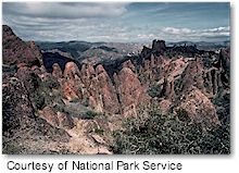
 Rising out of the chaparral-covered Gabilan Mountains, east of central California's Salinas Valley, are the spectacular remains of an ancient volcano. Massive monoliths, spires, sheer-walled canyons and talus passages define millions of years of erosion, faulting and tectonic plate movement. Within the monument's boundaries lie 24,000 acres of diverse wildlands. The monument is renowned for the beauty and variety of its spring wildflowers. A rich diversity of wildlife can be observed throughout the year. Rising out of the chaparral-covered Gabilan Mountains, east of central California's Salinas Valley, are the spectacular remains of an ancient volcano. Massive monoliths, spires, sheer-walled canyons and talus passages define millions of years of erosion, faulting and tectonic plate movement. Within the monument's boundaries lie 24,000 acres of diverse wildlands. The monument is renowned for the beauty and variety of its spring wildflowers. A rich diversity of wildlife can be observed throughout the year.
The rock formations of Pinnacles National Monument divide the park into East and West Districts which are connected by trails, but not by a vehicle road. More than 30 miles of trails access geological formations, spectacular vistas and wildland communities. The Pinnacles' rock formations are a popular destination to challenge technical climbers. Pinnacles is a day-use park, with occasional full moon hikes and dark sky astronomical observations led by ranger-interpreters.
Pinnacles National Monument is primarily a hiking park, and there are over 30 miles of trails, from easy two-mile loops to strenuous trails that go through the heart of the High Peaks rock formation.
Fees:
Vehicle: $5.00
Walk-in: $3.00
Pinnacles Annual Pass: $15.00
Getting There:
Pinnacles National Monument has two entrances: east and west. The west entrance can be reached via Highway 101 near the town of Soledad, then east along Highway 146 to the Chaparral area. The east entrance is reached via Highway 25, south of the city of Hollister and north of the town of King City, then west on Highway 146. The entrances are NOT connected by a road. It is not possible to drive through the Monument from one side to the other.
|


