|
 Threading its way across our landscape, the North Country National Scenic Trail (NST) links outstanding scenic, natural, recreational, historic, and cultural areas in seven of our northern tier states - New York, Pennsylvania, Ohio, Michigan, Wisconsin, Minnesota, and North Dakota. The eastern end of the trail is at New York's
Crown Point State Historic Site on the shore of Lake Champlain. The western end is at
Lake Sakakawea State Park in west central North Dakota where it joins the route of the Lewis & Clark National Historic Trail. Threading its way across our landscape, the North Country National Scenic Trail (NST) links outstanding scenic, natural, recreational, historic, and cultural areas in seven of our northern tier states - New York, Pennsylvania, Ohio, Michigan, Wisconsin, Minnesota, and North Dakota. The eastern end of the trail is at New York's
Crown Point State Historic Site on the shore of Lake Champlain. The western end is at
Lake Sakakawea State Park in west central North Dakota where it joins the route of the Lewis & Clark National Historic Trail.
The North Country National Scenic Trail links scenic, natural, historic, and cultural areas. The approximately four thousand mile long trail
includes a variety of hikes from easy walking to challenging treks.
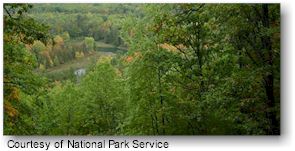
Whether used for an afternoon of walking, a day of cross-country skiing, or a week or month(s) of backpacking, adventure is found along the trail-forested pathways, marshes and bogs, waterfalls, sand dunes, tallgrass prairies, old logging railroad grades, lighthouses, Revolutionary War forts, and small rural communities. From the Missouri River in North Dakota to the shore of Lake Champlain in New York, diverse features along the trail communicate how the land was formed, how it has been settled, and how it has been used and altered by mankind.
When completed, through the efforts of many people, the trail will become the longest continuous hiking trail in the United States. From the Missouri River in North Dakota to the shores of Lake Champlain in New York, the trail allows hikers to experience a variety of features, from clear-flowing streams, to thick Northern woods, from vast prairies to clean lakes.
Come and experience your America, at a walking pace.
Getting There:
The North Country National Scenic Trail is designed for foot travel. Public roads and highways access the North Country National Scenic Trail at numerous locations.
|


