|
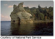
 Multicolored sandstone cliffs, beaches, sand dunes, waterfalls,
inland lakes, wildlife and the forest of the Lake Superior shoreline
beckon visitors to explore this 73,000+ acre park.
Attractions include a lighthouse and former
Coast Guard life-saving stations along with old farmsteads and
former logging trails. The park is a four season recreational
destination where hiking, camping, hunting, nature study, and
winter activities abound. At its widest point the Lakeshore
is only five miles and hugs the Superior shoreline for more
than 40 miles. This was the first National Lakeshore and was
authorized in 1966.
Mission Statement of Pictured Rocks National
Lakeshore: Our shared mission is to conserve the ecosystem integrity
of Pictured Rocks National Lakeshore, a mosaic of geologic,
biologic, scenic, and historic features, offering opportunities
for recreation, education, inspiration and enjoyment forever.
Facilities
Pictured Rocks/Hiawatha
Forest Visitor Information Center
- Visitors to the lakeshore area should begin their
stay with a visit to the Pictured Rocks National Lakeshore/Hiawtha
National Forest Visitor Information Center. There you can
obtain information on a variety of recreation resources
in the lakeshore and the Hiawatha National Forest area.
The center also maintains schedules of interpretive activities
presented by Park and Forest Rangers. The center also features
an attractive pictorial exhibit area and a Hiawatha Interpretive
Association sales area where visitors can purchase posters,
slides, and a variety of publications which will foster
a greater understanding of the region. Located at the junction
of state highway M-28 and county road H-58 in Munising.
(906) 387-3700.
Grand Sable Visitor
Center - Nestled at the foot of the Grand Sable Dunes,
the Grand Sable Visitor Center is located near the east
end of the lakeshore and the beginning of the Lakeshore
segment of the North Country Trail. A Park Ranger is on
duty to assist hikers, backpackers, and nature enthusiasts
with information geared at making their stay more enjoyable.
A bookstore is located here as well. E21090 Country Road
H58, one mile west of Grand Marais. (906) 494-2660.
Miners Castle Information
Station - Miners Castle facilities include restrooms,
paved overlook trails, wayside exhibits, and access to the
North Country Trail. The Miners Castle Information Station
includes a small Eastern National cooperating association
bookstore. End of Miners Castle Road, 6 miles north of county
road H-58.
Munising Falls Interpretive
Center - Located next
to Munising Falls, the interpretive center features displays
on the rich natural and cultural history of Pictured Rocks
National Lakeshore. Exhibits on early iron smelting, geology,
forest history, rare and endangered species, logging, and
recreation portray the diversity of our nation's first national
lakeshore.1505 Sand Point Road in Munising (across from
Munising Memorial Hospital).
Getting There:
Michigan state highways M-28 and M-94 lead to Munising; state
highway M-77 leads to Grand Marais. County road H-58 and other
spur roads provide access throughout the park.
|


